


- High-grade intersections expand South Mine Complex ("SMC") to the east
° Key intercepts: 118.8 g/t over 2.0 m core length (Unidentified Hanging Wall Zone),
62.7 g/t over 1.9 m true width (New South Zone), and
73.8 g/t over 2.7 m true width (New South Zone)
- SMC intersected 250 m west of current Mineral Resource
° Key intercepts: 4,772.2 g/t over 2.0 m core length (Unidentified HW Zone),
436.9 g/t over 2.8 m core length (Unidentified HW Zone), and
436.9 g/t over 2.8 m core length (New South Zone)
158.0 g/t over 2.4 m true width (Lower SMC)
- High-grade intersections expand Lower SMC to east and to depth
° Key intercepts: 2,458.6 g/t over 1.8 m true width (Lower SMC)
523.1 g/t over 2.0 m core length (Lower SMC), and
20.0 g/t over 3.8 m true width (Lower SMC)
- New drilling, reinterpretation of historic holes, identifies two new areas of high-grade mineralization on Amalgamated Break
° Key intercepts: 429.1 g/t over 2.7 m true width (New drilling) (Amalgamated East),
164.8 g/t over 2.1 m true width (New drilling) (Amalgamated East), and
26.7 g/t over 1.2 m true width (New drilling) (Amalgamated East)
827.9 g/t over 2.0 m core length (Reinterpretation) (Amalgamated West),
360.9 g/t over 2.0 m core length (Reinterpretation) (Amalgamated West),
333.8 g/t over 2.0 m core length (Reinterpretation) (Amalgamated West).
TORONTO, May 02, 2019 (GLOBE NEWSWIRE) -- Kirkland Lake Gold Ltd. ("Kirkland Lake Gold" or the "Company") KL KL KLA today reported new high-grade drill intersections from underground exploration drilling within the SMC at the Macassa Mine, Kirkland Lake, Ontario. Results reported herein include 73 drill holes for 29,643 m of underground drilling from the east and west exploration drifts on the 5300-foot level ("5300 Level") as well as from the 5700 Level Ramp Development ("5700 Ramp"). Underground drilling from the 5300 Level and 5700 Ramp will continue throughout the remainder of 2019. The Company's recent underground exploration drilling efforts have utilized three drill rigs to focus on four main target areas – SMC East, SMC West, Lower SMC and the Amalgamated Break.
|
||||||||||||||||||||
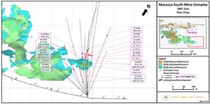
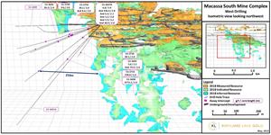
A total of 14 drill holes for 6,940 m drilled to the east of the SMC from the 5300 Level exploration drift intersected high-grade mineralization up to 60 m outside of existing Mineral Resources (Figure 1). A total of 11 drill holes for 5,396 m of drilling were completed from the 5300 Level west exploration drift targeting the New South and Lower SMC zones. This drilling intersected a mineralized zone, interpreted to be the Lower SMC, approximately 250 m west of the current Mineral Resources. An additional 40 drill holes for 15,990 m were completed from the 5700 Level ramp development, which intersected high-grade mineralization and successfully expanded the Lower SMC Zone. Refer to Table 1 for a completed list of drill hole results.
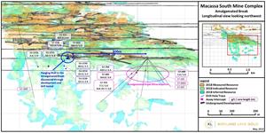
The Amalgamated Break provides areas of substantial exploration potential for Macassa that are largely untested with past drilling. In Q1 2019, preliminary drilling from the 5700 Level ramp development (8 holes for 1,317 m) successfully intersected a previously unidentified area of high-grade mineralization tightly associated with the Amalgamated Break. In addition, reinterpretation of intercepts from 15 previously drilled holes (2,953 m) from the 5700 Level ramp and five previously drilled holes (1,494 m) from the 5300 Level drift has resulted in the identification of a new, steep north-dipping mineralized zone north of, and likely associated with, the Amalgamated Break. This new zone remains open and represents a highly prospective target area for the addition of new resource ounces.
Tony Makuch, President and CEO of Kirkland Lake Gold, commented: "Today's results highlight what we have often said, that while it is a historic mine, Macassa is a modern operation, with high-grade, low-cost production and substantial exploration potential that will support mining well into the future. Early drilling in 2019 has successfully identified high-grade mineralization to the east, west and well below our existing Mineral Resource base in the SMC. In addition, areas running along the Amalgamated Break are extremely high-potential targets, the exploration of which will be enhanced immensely once we can drive underground exploration drifts off the #4 Shaft following its completion. While not generally well understood, these areas represent a whole new chapter for exploration in the Kirkland Lake camp. At surface, the Amalgamated Break is a fault that runs parallel to the Main/'04 Break, the source for most of Kirkland Lake's 25 million ounces of historic gold production. Unlike the Main/'04 Break, the Amalgamated Break is largely unexplored. The SMC is the first major high-grade zone discovered that is associated with the Amalgamated Break, and we are confident that there could be many more. In fact, with limited drilling, we have already identified two new areas of high-grade mineralization along the Break near our current mining operations. We will follow up on these results over the balance of this year and plan to expand our exploration efforts going forward."
SMC East
A total of 14 drill holes and 6,940 m of drilling has recently been completed from the 5300 Level east exploration drift targeting the New South and Footwall zones. Exploration efforts continue to intersect high grade mineralization outside of the current resource area supporting further resource growth. Drill holes of note in this area include: 53-3628 (62.7 g/t over 1.9 m true width (New South Zone)), 53-3572 (118.8 g/t over 2.0 m core length (unidentified HW zone, true width unknown)), 53-3623A (73.8 g/t over 2.7 m true width (New South Zone)). Ongoing exploration development to the east on 5300 Level in Q1 and excavation of diamond drill bay 165 m east of the current drill bay will allow for further testing of the SMC with the potential for resource growth. A diamond drill was mobilized into this new drill bay and commenced drilling at the end of Q1 and will continue to drill targets from this platform through 2019.
SMC West
A total of 11 drill holes for 5,396 m of drilling has recently been completed from the 5300 Level west exploration drift targeting the New South and Lower SMC zones. Completion of a diamond drill bay on the 5300 Level west exploration drift at the end of 2018 allowed for the mobilization of a diamond drill to the platform and commencement of drilling early in 2019. Phase 1 of the drilling program was designed to test the general mineralizing potential of the area with wide spaced holes. Initial efforts have intersected a mineralized zone, interpreted to be the Lower SMC, approximately 250 m west of the current resource (Figure 2). This significant step out is an early indication of the potential for future resource growth in this area. Drilling also resulted in several high-grade intercepts that will require further follow up to confirm geometry. Drill holes of note in this area include: 53-3697A (436.9 g/t over 2.8 m core length (New South Zone)), 53-3733 (158.0 g/t over 2.4 m true width (Lower SMC)), 53-3695 (79.0 g/t over 1.0 m true width (Lower SMC)), 53-3698 (4,772.2 g/t over 2.0 m core length (unidentified HW zone, true width unknown)) and 53-3697A (436.9 g/t over 2.8 m core length (unidentified HW zone, true width unknown)). Phase 2 of this drilling will focus on closer spaced drilling in an effort to add resource ounces to the current inventory. Exploration development continues to the west on the 5300 Level and excavation of a new diamond drill bay 165 m west of the current drill bay is anticipated later in Q2. Drilling from this new drill bay is anticipated to commence in Q2 and will allow for drilling coverage of a significant area west of the current SMC resource and testing of target areas deep on the '04 Break.
Lower SMC
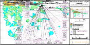
A total of 40 drill holes for 15,990 m of drilling has been completed from the 5700 Ramp development targeting the central part of the Lower SMC. The drill program was designed to test outside of the current resource area. This drill program has been successful in expanding the Lower SMC zone in this area and shows potential for addition of resource ounces. Drill holes of note in this area include: 57-625 (2,458.6 g/t over 1.8 m true width (Lower SMC)), 57-658 (523.1 g/t over 2.0 m core length (unidentified HW zone, true width unknown)), and 57-622 (20.0 g/t over 3.8 m true width (Lower SMC)). The current drill program has been completed and the drill has been mobilized to the far east drill bay on the 5300 Level to test the east extension of the SMC.
Amalgamated Break East and West
A total of 8 drill holes for 1,317 m of drilling is being reported from the 5700 Ramp targeting the Amalgamated Break to the east. This early stage drilling program has identified an area of high-grade mineralization tightly associated with the Amalgamated Break. The Amalgamated Break has been largely untested and represents an important emerging exploration target which remains open and represents a highly prospective target area for the addition of new resource ounces. Drill holes of note in this area include: 57-704 (429.1 g/t over 2.7 m true width), 57-689 (164.8 g/t over 2.1 m true width) and 57-703 (26.7 g/t over 1.2 m true width). Drilling to follow up on the down dip and western extent of this mineralization will continue in Q2 and will continue throughout 2019 if warranted by further positive results.
Reinterpretation of intercepts from 15 production drill holes (2,953 m) drilled to the west from the 5700 Ramp development and five exploration drill holes (1,494 m) drilled to the west from the 5300 Level has outlined a steep north-dipping mineralized zone north of and in the immediate hanging wall of the Amalgamated Break. This zone remains open and represents a highly prospective target area for the addition of new resource ounces. Drill holes of note in this area include: 57-425 (827.9 g/t over 2.0 m core length (Amalgamated West)), 57-423 (360.9 g/t over 2.0 m core length (Amalgamated West)), 57-418 (333.8 g/t over 2.0 m core length (Amalgamated West)). Refer to Table 2 for the complete list of production and reinterpreted drill holes. Additional drilling in this area is planned from the 5700 Ramp development in Q2 and will continue throughout 2019 if warranted by further positive results.
2019 Underground Exploration Development
Underground development on the 5300 Level will be ongoing throughout 2019 and is scheduled to include 350 m of advancement to the east and 429 m of advancement to the west including all track development and the excavation of diamond drill bays. This development is part of an ongoing effort to expand the SMC in all directions and to test for and define new target areas.
To view a PDF of the figures referenced in this News Release, visit the links below. Tables are provided at the end of this News Release.
Figure 1:
A photo accompanying this announcement is available at http://www.globenewswire.com/NewsRoom/AttachmentNg/e13f3528-a49e-4636-8f4a-46aaf10e3cb4
Figure 2:
A photo accompanying this announcement is available at http://www.globenewswire.com/NewsRoom/AttachmentNg/bd167d97-8d35-4187-bbf0-0228eaf719cd
Figure 3:
A photo accompanying this announcement is available at http://www.globenewswire.com/NewsRoom/AttachmentNg/a57aaa3f-e3e0-4731-8d3a-ab34ec6c5849
Figure 4:
A photo accompanying this announcement is available at http://www.globenewswire.com/NewsRoom/AttachmentNg/17bf67c3-66b7-41c9-b539-2c85ff12f0b2
Qualified Person
The Company's exploration programs at Macassa are conducted under the supervision of Eric Kallio, P.Geo., Senior Vice President, Exploration. Eric Kallio is the ‘qualified person' for the purpose of National Instrument 43-101, Standards of Disclosure for Mineral Projects, of the Canadian Securities Administrators, and has reviewed and approved the scientific and technical information in this news release.
QA/QC Controls
The Company has implemented a quality assurance and control ("QA/QC") program to ensure sampling and analysis of all exploration work is conducted in accordance with best practices. Samples are logged and sampled in a secure facility at the Macassa mine site and under supervision of Qualified Geologists. BQ sized core is sawn in half with one half of the core being shipped to Swastika Laboratories in Swastika, Ontario and the other half retained for future assay verification. Assaying of the samples is completed using Fire Assay techniques with samples less than 6 gpt being analyzed with Atomic Absorption (AA) and samples greater than 6 gpt with gravimetric finish. Selected high grade samples are also analyzed using the screen metallics procedure. Other QA/QC includes the insertion of certified reference standards, blanks and the regular re-assaying of pulps and rejects at alternate certified laboratories. The laboratory re-assays at least 10% of all samples and additional checks may be run on anomalous values.
About Kirkland Lake Gold Ltd.
Kirkland Lake Gold Ltd. is a growing gold producer operating in Canada and Australia that produced 723,701 ounces in 2018 and is on track to achieve significant production growth over the next three years, including target production of 920,000 – 1,000,000 ounces in 2019, 930,000 – 1,010,000 ounces in 2020 and 995,000 – 1,055,000 ounces in 2021. The production profile of the Company is anchored by two high-grade, low-cost operations, including the Macassa Mine located in Northern Ontario and the Fosterville Mine located in the state of Victoria, Australia. Kirkland Lake Gold's solid base of quality assets is complemented by district scale exploration potential, supported by a strong financial position with extensive management and operational expertise.
For further information on Kirkland Lake Gold and to receive news releases by email, visit the website www.klgold.com.
Cautionary Note Regarding Forward-Looking Information
This Press Release contains statements which constitute "forward-looking statements" within the meaning of applicable securities laws, including statements regarding the plans, intentions, beliefs and current expectations of the Company with respect to the future business activities and operating performance of the Company. The words "may", "would", "could", "should", "will", "intend", "plan", "anticipate", "believe", "estimate", "expect" and similar expressions, as they relate to the Company, are intended to identify such forward-looking statements. Investors are cautioned that forward-looking statements are based on the opinions, assumptions and estimates of management considered reasonable at the date the statements are made such as, without limitation, opinion, assumptions and estimates of management regarding the Company's business, including but not limited to; the continued exploration programs on the SMC mineralization, the timing and results thereof; the ability to continue to expand the SMC and to increase its level of resources and the timing thereof; the potential to increase the level of resources and reserves and potential conversion of mineral resources; the anticipated completion date of the #4 shaft and potential impact and benefits thereof; the amount of future production over any period; and assumptions made relating to operating cash costs based on forecasts and projections. Such opinions, assumptions and estimates, are inherently subject to a variety of risks and uncertainties and other known and unknown factors that could cause actual events or results to differ materially from those projected in the forward-looking statements. These factors include the Company's expectations in connection with the projects and exploration programs being met, the impact of general business and economic conditions, global liquidity and credit availability on the timing of cash flows and the values of assets and liabilities based on projected future conditions, fluctuating gold prices, currency exchange rates (such as the Canadian dollar versus the United States Dollar), possible variations in ore grade or recovery rates, changes in accounting policies, changes in the Company's corporate mineral reserves and resources, changes in project parameters as plans continue to be refined, changes in project development, construction, production and commissioning time frames, the possibility of project cost overruns or unanticipated costs and expenses, higher prices for fuel, power, labour and other consumables contributing to higher costs and general risks of the mining industry, failure of plant, equipment or processes to operate as anticipated, unexpected changes in mine life, seasonality and unanticipated weather changes, costs and timing of the development of new deposits, success of exploration activities, permitting time lines, government regulation of mining operations, environmental risks, unanticipated reclamation expenses, title disputes or claims, and limitations on insurance, as well as those risk factors discussed or referred to in the Company's annual Management's Discussion and Analysis and Annual Information Form for the year ended December 31, 2017, filed with the securities regulatory authorities in certain provinces of Canada and available at www.sedar.com.
Should one or more of these risks or uncertainties materialize, or should assumptions underlying the forward-looking statements prove incorrect, actual results may vary materially from those described herein as intended, planned, anticipated, believed, estimated or expected. Although the Company has attempted to identify important risks, uncertainties and factors which could cause actual results to differ materially, there may be others that cause results not to be as anticipated, estimated or intended. The Company does not intend, and does not assume any obligation, to update these forward-looking statements except as otherwise required by applicable law.
Cautionary Note to U.S. Investors - Mineral Reserve and Resource Estimates
All resource and reserve estimates included in this news release or documents referenced in this news release have been prepared in accordance with Canadian National Instrument 43-101 - Standards of Disclosure for Mineral Projects ("NI 43-101") and the Canadian Institute of Mining, Metallurgy and Petroleum (the "CIM") - CIM Definition Standards on Mineral Resources and Mineral Reserves, adopted by the CIM Council, as amended (the "CIM Standards"). NI 43-101 is a rule developed by the Canadian Securities Administrators, which established standards for all public disclosure an issuer makes of scientific and technical information concerning mineral projects. The terms "mineral reserve", "proven mineral reserve" and "probable mineral reserve" are Canadian mining terms as defined in accordance with NI 43-101 and the CIM Standards. These definitions differ materially from the definitions in SEC Industry Guide 7 ("SEC Industry Guide 7") under the United States Securities Act of 1933, as amended, and the Exchange Act.
In addition, the terms "Mineral Resource", "measured Mineral Resource", "indicated Mineral Resource" and "Inferred Mineral Resource" are defined in and required to be disclosed by NI 43-101 and the CIM Standards; however, these terms are not defined terms under SEC Industry Guide 7 and are normally not permitted to be used in reports and registration statements filed with the U.S. Securities and Exchange Commission (the "SEC"). Investors are cautioned not to assume that all or any part of mineral deposits in these categories will ever be converted into reserves. "Inferred Mineral Resources" have a great amount of uncertainty as to their existence, and great uncertainty as to their economic and legal feasibility. It cannot be assumed that all or any part of an Inferred Mineral Resource will ever be upgraded to a higher category. Under Canadian rules, estimates of Inferred Mineral Resources may not form the basis of feasibility or pre-feasibility studies, except in very limited circumstances. Investors are cautioned not to assume that all or any part of a Mineral Resource exists, will ever be converted into a Mineral Reserve or is or will ever be economically or legally mineable or recovered.
FOR FURTHER INFORMATION PLEASE CONTACT
Anthony Makuch, President, Chief Executive Officer & Director
Phone: +1 416-840-7884
E-mail: tmakuch@klgold.com
Mark Utting, Vice-President, Investor Relations
Phone: +1 416-840-7884
E-mail: mutting@klgold.com
Table 1: Complete List of Reported Drill Holes
| DRILL HOLE | EASTING | NORTHING | ELEVATION (m) | HOLE LENGTH (m) | AZI | DIP (°) | Target | FROM (m) | TO (m) | CORE LENGTH (m) | True Width (m) | Grade Au (g/t) | Cut Grade (g/t) | Zone |
| 53-3570 | 570026 | 5331721 | -1261 | 457 | 325 | -64 | East | NSV | ||||||
| 53-3571 | 570026 | 5331721 | -1261 | 466 | 329 | -60 | East | 245.5 | 249.0 | 3.6 | 3.4 | 3.2 | 1-12 | |
| Including | 248.1 | 249.0 | 0.9 | 0.9 | 7.9 | |||||||||
| AND | 256.0 | 259.1 | 3.0 | 4.5 | ||||||||||
| AND | 326.9 | 328.9 | 2.0 | 31.4 | ||||||||||
| Including | 327.5 | 328.1 | 0.6 | 96.9 | ||||||||||
| 53-3572 | 570026 | 5331721 | -1261 | 442 | 343 | -67 | East | 177.1 | 179.1 | 2.0 | 118.8 | |||
| Including | 177.8 | 178.2 | 0.4 | 650.2 | ||||||||||
| AND | 260.9 | 264.0 | 3.0 | 2.8 | 3.2 | 1-12 | ||||||||
| Including | 262.4 | 262.7 | 0.3 | 0.3 | 10.0 | |||||||||
| 53-3573 | 570025 | 5331722 | -1261 | 516 | 350 | -49 | East | 255.8 | 257.8 | 2.0 | 2.0 | 8.7 | 1-12 | |
| Including | 255.8 | 256.8 | 1.0 | 1.0 | 16.7 | |||||||||
| AND | 262.7 | 264.7 | 2.0 | 6.1 | ||||||||||
| Including | 264.0 | 264.3 | 0.3 | 38.8 | ||||||||||
| AND | 283.6 | 290.2 | 6.5 | 4.7 | ||||||||||
| Including | 287.7 | 290.2 | 2.5 | 8.5 | ||||||||||
| 53-3574 | 570026 | 5331721 | -1261 | 488 | 354 | -58 | East | 254.2 | 256.2 | 2.0 | 2.0 | 15.0 | 1-12 | |
| Including | 254.9 | 255.3 | 0.5 | 0.5 | 55.9 | |||||||||
| AND | 332.8 | 334.8 | 2.0 | 32.7 | ||||||||||
| Including | 333.8 | 334.8 | 1.1 | 60.5 | ||||||||||
| 53-3575 | 570025 | 5331722 | -1261 | 549 | 356 | -48 | East | NSV | ||||||
| 53-3576 | 570025 | 5331723 | -1261 | 686 | 357 | -36 | East | 257.1 | 261.8 | 4.7 | 4.6 | 9.3 | 1-12 | |
| Including | 257.1 | 257.6 | 0.5 | 0.5 | 38.8 | |||||||||
| Including | 261.2 | 261.8 | 0.6 | 0.6 | 25.3 | |||||||||
| 53-3577 | 570026 | 5331722 | -1261 | 503 | 0 | -55 | East | 253.3 | 255.3 | 2.0 | 2.0 | 31.9 | 1-12 | |
| Including | 254.8 | 255.1 | 0.3 | 0.3 | 181.2 | |||||||||
| AND | 280.2 | 282.2 | 2.0 | 15.6 | ||||||||||
| Including | 280.4 | 280.8 | 0.4 | 79.1 | ||||||||||
| 53-3578 | 570025 | 5331724 | -1261 | 597 | 359 | -33 | East | NSV | ||||||
| 53-3579 | 570027 | 5331722 | -1261 | 447 | 22 | -59 | East | NSV | ||||||
| 53-3619A | 570026 | 5331721 | -1261 | 408 | 309 | -48 | East | NSV | ||||||
| 53-3620 | 570026 | 5331721 | -1261 | 396 | 312 | -55 | East | 253.9 | 260.3 | 6.4 | 5.9 | 9.1 | 1-12 | |
| Including | 253.9 | 256.0 | 2.1 | 2.0 | 22.1 | |||||||||
| Including | 253.9 | 254.5 | 0.6 | 0.5 | 71.7 | |||||||||
| Including | 259.7 | 260.3 | 0.6 | 0.5 | 16.2 | |||||||||
| 53-3623A | 570025 | 5331722 | -1261 | 503 | 343 | -44 | East | 314.4 | 317.3 | 2.9 | 2.7 | 73.8 | 1-12 | |
| Including | 316.2 | 317.3 | 1.1 | 1.0 | 197.4 | |||||||||
| 53-3628 | 570026 | 5331723 | -1261 | 482 | 10 | -49 | East | 266.9 | 268.9 | 2.0 | 1.9 | 62.7 | 43.6 | 1-12 |
| Including | 267.6 | 267.9 | 0.3 | 0.3 | 400.3 | 274.3 | ||||||||
| AND | 418.2 | 420.2 | 2.0 | 10.8 | ||||||||||
| Including | 418.8 | 419.7 | 0.9 | 21.5 | ||||||||||
| 53-3685 | 568756 | 5331152 | -1264 | 305 | 128 | -74 | West SMC | NSV | ||||||
| 53-3690 | 568756 | 5331152 | -1264 | 969 | 287 | -3 | West SMC | NSV | ||||||
| 53-3691A | 568756 | 5331152 | -1264 | 579 | 295 | -46 | West | NSV | ||||||
| 53-3692 | 568756 | 5331152 | -1264 | 305 | 293 | -22 | West | 170.4 | 172.8 | 2.4 | 0.8 | 26.3 | ||
| Including | 170.4 | 171.6 | 1.2 | 0.4 | 47.2 | |||||||||
| 53-3695 | 568756 | 5331152 | -1264 | 494 | 307 | -32 | West | 87.5 | 89.7 | 2.2 | 3.0 | |||
| Including | 88.7 | 89.7 | 1.0 | 5.0 | ||||||||||
| AND | 376.1 | 378.1 | 2.0 | 1.0 | 79.0 | 3-0 | ||||||||
| Including | 376.6 | 377.3 | 0.8 | 0.3 | 208.0 | |||||||||
| 53-3697A | 568756 | 5331152 | -1264 | 610 | 312 | -18 | West | 57.9 | 61.8 | 3.9 | 6.8 | |||
| Including | 57.9 | 58.8 | 0.8 | 25.4 | ||||||||||
| AND | 135.2 | 138.0 | 2.8 | 436.9 | ||||||||||
| Including | 135.6 | 136.8 | 1.2 | 1015.8 | ||||||||||
| AND | 139.6 | 141.7 | 2.1 | 6.4 | ||||||||||
| AND | 143.9 | 146.7 | 2.8 | 3.2 | ||||||||||
| AND | 157.3 | 160.5 | 3.2 | 1.9 | 5.9 | |||||||||
| AND | 415.7 | 417.7 | 2.0 | 1.4 | 30.0 | 3-17 | ||||||||
| Including | 415.7 | 416.8 | 1.1 | 0.8 | 54.6 | |||||||||
| 53-3698 | 568756 | 5331152 | -1264 | 396 | 313 | -40 | West | 216.5 | 218.5 | 2.0 | 4772.2 | |||
| Including | 216.5 | 216.9 | 0.4 | 26211.7 | ||||||||||
| 53-3733 | 568756 | 5331152 | -1264 | 427 | 345 | -25 | West | 346.9 | 349.3 | 2.4 | 2.4 | 158.0 | 23.5 | 3-17 |
| Including | 347.5 | 348.1 | 0.6 | 0.6 | 621.4 | 83.5 | ||||||||
| Including | 347.8 | 348.1 | 0.3 | 0.3 | 1178.6 | 102.9 | ||||||||
| 53-3734 | 568756 | 5331152 | -1264 | 168 | 23 | -35 | West | 102.4 | 104.4 | 2.0 | 1.8 | 30.1 | ||
| Including | 102.4 | 103.0 | 0.6 | 0.5 | 90.2 | |||||||||
| 53-3749 | 568756 | 5331152 | -1264 | 565 | 311 | -13 | West | 183.4 | 185.4 | 2.0 | 2.0 | 9.6 | 5-14 | |
| Including | 185.0 | 185.4 | 0.4 | 0.4 | 50.3 | |||||||||
| 53-3750 | 568756 | 5331152 | -1264 | 579 | 310 | -16 | West | 156.1 | 158.1 | 2.0 | 1.1 | 30.5 | ||
| Including | 157.2 | 157.9 | 0.6 | 0.3 | 92.4 | |||||||||
| AND | 309.6 | 311.6 | 2.0 | 1.0 | 8.4 | |||||||||
| 57-580 | 569222 | 5331378 | -1398 | 126 | 38 | -62 | Lower SMC | NSV | ||||||
| 57-581 | 569222 | 5331378 | -1398 | 396 | 39 | -55 | Lower SMC | 212.7 | 214.7 | 2.0 | 1.8 | 6.4 | 1-53 | |
| Including | 213.4 | 214.1 | 0.7 | 0.6 | 17.3 | |||||||||
| AND | 324.2 | 326.7 | 2.5 | 1.8 | 3.4 | 3-14 | ||||||||
| 57-583 | 569221 | 5331374 | -1398 | 427 | 47 | -56 | Lower SMC | 73.8 | 76.7 | 3.0 | 7.9 | |||
| AND | 196.7 | 198.7 | 2.0 | 5.1 | ||||||||||
| Including | 197.6 | 198.1 | 0.5 | 14.4 | ||||||||||
| AND | 346.3 | 348.4 | 2.0 | 1.2 | 3.2 | 3-14 | ||||||||
| 57-584A | 569221 | 5331374 | -1398 | 460 | 55 | -60 | Lower SMC | 189.7 | 191.7 | 2.0 | 4.3 | |||
| Including | 190.7 | 191.1 | 0.4 | 21.2 | ||||||||||
| AND | 205.4 | 207.4 | 2.0 | 1.8 | 72.5 | 1-53 | ||||||||
| Including | 206.3 | 206.7 | 0.4 | 0.3 | 342.2 | |||||||||
| AND | 319.8 | 322.8 | 3.0 | 5.1 | ||||||||||
| 57-585 | 569221 | 5331374 | -1398 | 518 | 302 | -56 | Lower SMC | 413.2 | 415.2 | 2.0 | 1.4 | 13.6 | 3-14 | |
| Including | 413.5 | 414.0 | 0.5 | 0.3 | 52.1 | |||||||||
| AND | 432.1 | 434.2 | 2.0 | 3.3 | ||||||||||
| 57-586 | 569221 | 5331374 | -1398 | 40 | 309 | -61 | Lower SMC | Hole Restarted | ||||||
| 57-586A | 569221 | 5331374 | -1398 | 472 | 312 | -55 | Lower SMC | 69.8 | 71.8 | 2.0 | 6.4 | 1-37? | ||
| Including | 71.0 | 71.8 | 0.8 | 14.6 | ||||||||||
| AND | 272.6 | 274.6 | 2.0 | 13.2 | ||||||||||
| AND | 393.4 | 395.4 | 2.0 | 1.3 | 33.7 | 3-14 | ||||||||
| Including | 394.3 | 394.8 | 0.5 | 0.3 | 134.6 | |||||||||
| 57-588 | 569221 | 5331374 | -1398 | 456 | 317 | -59 | Lower SMC | 365.7 | 368.2 | 2.5 | 12.7 | |||
| Including | 367.8 | 368.2 | 0.3 | 83.6 | ||||||||||
| 57-607 | 569221 | 5331374 | -1398 | 375 | 19 | -54 | Lower SMC | 278.9 | 280.9 | 2.0 | 1.8 | 3.4 | 3-14 | |
| 57-609 | 569221 | 5331374 | -1398 | 488 | 19 | -74 | Lower SMC | 293.9 | 295.9 | 2.0 | 3.5 | |||
| AND | 425.8 | 430.4 | 4.6 | 1.8 | 7.4 | 3-14 | ||||||||
| Including | 425.8 | 427.0 | 1.2 | 0.5 | 16.2 | |||||||||
| Including | 429.6 | 430.4 | 0.8 | 0.3 | 13.9 | |||||||||
| 57-610 | 569221 | 5331374 | -1398 | 396 | 37 | -58 | Lower SMC | 332.8 | 334.8 | 2.0 | 1.3 | 5.5 | 3-14 | |
| Including | 332.8 | 333.2 | 0.4 | 0.3 | 24.9 | |||||||||
| 57-611 | 569222 | 5331374 | -1398 | 152 | 61 | -40 | Lower SMC | NSV - Target not reached | ||||||
| 57-612 | 569221 | 5331374 | -1398 | 274 | 68 | -53 | Lower SMC | NSV - Target not reached | ||||||
| 57-613 | 569222 | 5331374 | -1398 | 305 | 73 | -40 | Lower SMC | 92.1 | 95.0 | 2.9 | 4.1 | |||
| AND | 100.0 | 102.4 | 2.3 | 7.7 | ||||||||||
| 57-619 | 569221 | 5331374 | -1398 | 457 | 306 | -48 | Lower SMC | 409.5 | 411.5 | 2.0 | 1.3 | 6.4 | 3-14 | |
| Including | 409.9 | 410.8 | 0.9 | 0.6 | 13.9 | |||||||||
| 57-620 | 569221 | 5331374 | -1398 | 488 | 306 | -52 | Lower SMC | NSV | ||||||
| 57-621 | 569221 | 5331374 | -1398 | 457 | 309 | -46 | Lower SMC | NSV | ||||||
| 57-622 | 569221 | 5331374 | -1398 | 418 | 310 | -51 | Lower SMC | 161.8 | 163.8 | 2.0 | 3.1 | |||
| Including | 162.8 | 163.1 | 0.4 | 17.0 | ||||||||||
| AND | 197.5 | 199.6 | 2.0 | 12.6 | ||||||||||
| Including | 198.1 | 199.0 | 0.9 | 26.8 | ||||||||||
| AND | 391.0 | 393.0 | 2.0 | 6.0 | ||||||||||
| AND | 396.5 | 401.5 | 5.1 | 3.8 | 20.0 | 3-14 | ||||||||
| Including | 396.5 | 396.8 | 0.3 | 0.2 | 64.7 | |||||||||
| Including | 398.9 | 399.3 | 0.4 | 0.3 | 153.3 | |||||||||
| 57-623 | 569221 | 5331374 | -1398 | 457 | 312 | -56 | Lower SMC | 385.6 | 387.6 | 2.0 | 1.3 | 4.2 | 3-14 | |
| 57-624 | 569221 | 5331374 | -1398 | 392 | 320 | -60 | Lower SMC | NSV | ||||||
| 57-625 | 569221 | 5331374 | -1398 | 427 | 320 | -62 | Lower SMC | 342.3 | 345.2 | 2.8 | 1.8 | 2458.6 | 3-14 | |
| Including | 342.3 | 342.6 | 0.3 | 0.2 | 22469.3 | |||||||||
| Including | 344.6 | 345.2 | 0.6 | 0.4 | 206.8 | |||||||||
| AND | 357.7 | 361.8 | 4.1 | 3.9 | ||||||||||
| 57-626 | 569221 | 5331374 | -1398 | 488 | 322 | -65 | Lower SMC | 351.6 | 353.6 | 2.0 | 1.1 | 7.0 | 3-14 | |
| Including | 352.7 | 353.6 | 0.9 | 0.5 | 15.5 | |||||||||
| AND | 426.4 | 434.2 | 7.8 | 3.2 | ||||||||||
| 57-627 | 569221 | 5331374 | -1398 | 451 | 327 | -66 | Lower SMC | 441.7 | 443.7 | 2.0 | 15.8 | |||
| Including | 441.7 | 442.2 | 0.6 | 54.9 | ||||||||||
| 57-628 | 569221 | 5331374 | -1398 | 366 | 342 | -59 | Lower SMC | 180.0 | 182.0 | 2.0 | 3.9 | |||
| Including | 180.6 | 181.1 | 0.4 | 17.1 | ||||||||||
| 57-629 | 569221 | 5331374 | -1398 | 396 | 335 | -63 | Lower SMC | 310.3 | 312.3 | 2.0 | 1.4 | 66.2 | 3-14 | |
| Including | 310.9 | 311.5 | 0.6 | 0.4 | 228.8 | |||||||||
| 57-630A | 569221 | 5331374 | -1398 | 445 | 346 | -70 | Lower SMC | 173.3 | 175.6 | 2.3 | 6.0 | |||
| 57-631 | 569221 | 5331374 | -1398 | 456 | 27 | -67 | Lower SMC | NSV | ||||||
| 57-632 | 569221 | 5331374 | -1398 | 366 | 36 | -55 | Lower SMC | 208.8 | 210.8 | 2.0 | 1.9 | 4.3 | 1-53 | |
| Including | 209.9 | 210.2 | 0.3 | 0.3 | 27.9 | |||||||||
| 57-653 | 569221 | 5331374 | -1398 | 482 | 309 | -60 | Lower SMC | NSV | ||||||
| 57-654 | 569221 | 5331374 | -1398 | 480 | 349 | -55 | Lower SMC | NSV | ||||||
| 57-655 | 569221 | 5331374 | -1398 | 30 | 348 | -69 | Lower SMC | NSV - Hole Abandoned | ||||||
| 57-656 | 569221 | 5331374 | -1398 | 383 | 24 | -58 | Lower SMC | 200.2 | 202.2 | 2.0 | 1.9 | 32.4 | 1-53 | |
| Including | 201.0 | 201.4 | 0.3 | 0.3 | 166.0 | |||||||||
| 57-658 | 569221 | 5331374 | -1398 | 503 | 36 | -69 | Lower SMC | 96.0 | 98.0 | 2.0 | 523.1 | |||
| Including | 96.1 | 96.4 | 0.3 | 2827.9 | ||||||||||
| AND | 186.1 | 189.7 | 3.6 | 3.5 | 16.0 | 1-53 | ||||||||
| Including | 186.1 | 186.4 | 0.3 | 0.3 | 143.2 | |||||||||
| AND | 246.9 | 248.9 | 2.0 | 6.1 | ||||||||||
| Including | 247.6 | 248.1 | 0.5 | 26.7 | ||||||||||
| AND | 401.6 | 407.1 | 5.5 | 1.8 | 8.9 | 3-14 | ||||||||
| Including | 401.6 | 405.4 | 3.8 | 1.2 | 11.7 | |||||||||
| Including | 401.6 | 402.3 | 0.8 | 0.1 | 44.5 | |||||||||
| 57-682 | 569221 | 5331374 | -1398 | 396 | 36 | -46 | Lower SMC | 220.2 | 222.5 | 2.3 | 1.9 | 5.1 | 1-53 | |
| 57-683 | 569221 | 5331374 | -1398 | 443 | 46 | -58 | Lower SMC | NSV | ||||||
| 57-685 | 569221 | 5331374 | -1398 | 168 | 125 | -41 | AK BREAK | NSV | ||||||
| 57-686 | 569221 | 5331374 | -1399 | 49 | 136 | -50 | AK BREAK | Hole Restarted | ||||||
| 57-686A | 569221 | 5331374 | -1398 | 137 | 136 | -47 | AK BREAK | NSV | ||||||
| 57-687 | 569221 | 5331374 | -1398 | 137 | 176 | -53 | AK BREAK | NSV | ||||||
| 57-688 | 569221 | 5331374 | -1398 | 229 | 186 | -41 | AK BREAK | 69.3 | 71.3 | 2.0 | 2.0 | 5.0 | 3-26 | |
| Including | 69.4 | 69.8 | 0.4 | 0.4 | 19.2 | |||||||||
| 57-689 | 569221 | 5331374 | -1398 | 277 | 235 | -40 | AK BREAK | 94.5 | 97.5 | 3.0 | 2.1 | 164.8 | 3-26 | |
| Including | 95.3 | 95.7 | 0.5 | 0.3 | 770.2 | |||||||||
| 57-698 | 569221 | 5331374 | -1398 | 405 | 312 | -46 | Lower SMC | 376.7 | 378.7 | 2.0 | 4.8 | 3-14 | ||
| Including | 377.7 | 378.1 | 0.3 | 27.2 | ||||||||||
| 57-700 | 569221 | 5331374 | -1398 | 486 | 317 | -58 | Lower SMC | 345.4 | 347.4 | 2.0 | 1.3 | 26.4 | 3-14 | |
| Including | 345.4 | 346.2 | 0.8 | 0.5 | 66.7 | |||||||||
| 57-700A | 569221 | 5331374 | -1398 | 488 | 312 | -59 | Lower SMC | 407.4 | 410.1 | 2.7 | 3.3 | 3-14 | ||
| 57-701 | 569221 | 5331374 | -1398 | 472 | 4 | -72 | Lower SMC | NSV | ||||||
| 57-702 | 569221 | 5331374 | -1398 | 472 | 19 | -72 | Lower SMC | 179.0 | 181.1 | 2.0 | 3.6 | 1-53 | ||
| Including | 180.1 | 180.4 | 0.3 | 20.5 | ||||||||||
| AND | 269.3 | 271.3 | 2.0 | 3.2 | ||||||||||
| Including | 270.4 | 270.8 | 0.3 | 21.0 | ||||||||||
| AND | 431.3 | 433.3 | 2.0 | 39.6 | 3-14 | |||||||||
| Including | 432.0 | 432.5 | 0.5 | 140.3 | ||||||||||
| 57-703 | 569221 | 5331374 | -1398 | 168 | 241 | -46 | AK BREAK | 63.3 | 65.3 | 2.0 | 7.1 | |||
| Including | 64.7 | 65.3 | 0.6 | 23.3 | ||||||||||
| AND | 101.9 | 103.9 | 2.0 | 1.2 | 26.7 | 3-26 | ||||||||
| Including | 101.9 | 102.7 | 0.8 | 0.5 | 67.4 | |||||||||
| 57-704 | 569221 | 5331374 | -1398 | 152 | 228 | -44 | AK BREAK | 79.2 | 82.6 | 3.3 | 2.7 | 429.1 | 3-26 | |
| Including | 79.2 | 79.9 | 0.6 | 0.5 | 1986.7 | |||||||||
NSV = No significant value, VG = Visible Gold; Tell = Tellurides; *Cut = cut to 274.3 g/t for New South Zone and 102.9 g/t for Lower SMC.
The top cut only applies to New South Zone and Lower SMC where a statistical cut has been calculated. All other zones remain uncut.
* Assay result reported was completed at Macassa's on-site laboratory as part of a definition drilling program.
**As part of routine QA/QC procedures to verify a select sample of high-grade assay, the pulp from this sample was also sent to an off-site independent lab for assay.
| Drill Hole | EASTING | NORTHING | ELEVATION (m) | HOLE LENGTH (m) | AZIMUTH | DIP (°) | FROM (m) | TO (m) | CORE LENGTH (m) | Grade Au (g/t) |
| 57-418 | 568974 | 5331174 | -1389 | 69 | 287 | -45 | 23.6 | 25.5 | 2.0 | 333.8** |
| Including | 23.9 | 24.2 | 0.3 | 2097.3** | ||||||
| 57-419 | 568974 | 5331174 | -1388 | 144 | 302 | 1 | NSV | |||
| 57-420 | 568974 | 5331174 | -1388 | 122 | 300 | -6 | 11.6 | 13.6 | 2.0 | 10.1** |
| Including | 12.0 | 12.7 | 0.7 | 27.2** | ||||||
| 57-421 | 568974 | 5331175 | -1388 | 168 | 311 | 0 | NSV | |||
| 57-422 | 568974 | 5331175 | -1388 | 175 | 316 | 11 | 9.8 | 11.8 | 2.0 | 8.5* |
| Including | 10.5 | 11.0 | 0.6 | 22.2* | ||||||
| 57-423 | 568974 | 5331175 | -1388 | 160 | 323 | 10 | 10.2 | 12.2 | 2.0 | 360.9** |
| Including | 10.5 | 10.8 | 0.3 | 2325.7** | ||||||
| 57-424 | 568974 | 5331175 | -1388 | 168 | 322 | 2 | 10.8 | 12.7 | 2.0 | 45.6** |
| Including | 10.8 | 11.1 | 0.3 | 233.6** | ||||||
| 57-425 | 568974 | 5331175 | -1388 | 114 | 324 | -5 | 10.5 | 12.5 | 2.0 | 827.9** |
| Including | 11.1 | 11.8 | 0.7 | 2317.7** | ||||||
| 57-426 | 568975 | 5331175 | -1388 | 206 | -27 | 7 | 11.3 | 13.3 | 2.0 | 3.6* |
| 57-429 | 568975 | 5331175 | -1388 | 107 | -15 | -13 | 10.2 | 12.2 | 2.0 | 19.2** |
| 57-430 | 568975 | 5331175 | -1388 | 145 | -5 | 5 | NSV | |||
| 57-432 | 568976 | 5331175 | -1388 | 99 | 22 | -16 | 22.5 | 25.2 | 2.7 | 15.8** |
| Including | 22.5 | 23.6 | 1.1 | 31.4* | ||||||
| 57-439 | 568974 | 5331175 | -1389 | 457 | 318 | -36 | 14.8 | 18.1 | 3.3 | 17.3* |
| Including | 14.8 | 15.3 | 0.5 | 86.7* | ||||||
| 57-440 | 568974 | 5331175 | -1389 | 457 | 323 | -36 | 14.2 | 18.1 | 4.0 | 4.0* |
| 57-442 | 568975 | 5331175 | -1389 | 362 | -25 | -38 | 15.9 | 18.7 | 2.7 | 14.1** |
| 53-2150 | 568905 | 5331233 | -1266 | 213 | 118 | -58 | 156.7 | 158.6 | 2.0 | 53.5 |
| Including | 158.3 | 158.6 | 0.3 | 322.5 | ||||||
| 53-2253 | 568905 | 5331233 | -1266 | 229 | 131 | -66 | 178.2 | 180.7 | 2.5 | 32.9 |
| Including | 179.8 | 180.7 | 0.8 | 92.5 | ||||||
| 53-2230 | 568905 | 5331233 | -1266 | 213 | 129 | -67 | 187.5 | 189.5 | 2.0 | 33.5 |
| Including | 187.5 | 188.2 | 0.7 | 91.3 | ||||||
| 53-2255 | 568902 | 5331232 | -1266 | 610 | 183 | -66 | 177.8 | 182.1 | 4.4 | 16.7 |
| Including | 177.8 | 178.7 | 0.9 | 60.9 | ||||||
| Including | 181.6 | 182.1 | 0.5 | 24.4 | ||||||
| 53-2256 | 568901 | 5331232 | -1266 | 229 | 202 | -59 | 193.3 | 195.3 | 2.0 | 4.0 |
NSV = No significant value, VG = Visible Gold; Tell = Tellurides;
* Assay result reported was completed at Macassa's on-site laboratory as part of a definition drilling program.
**As part of routine QA/QC procedures to verify a select sample of high-grade assay, the pulp from this sample was also sent to an off-site independent lab for assay.


© 2024 Benzinga.com. Benzinga does not provide investment advice. All rights reserved.
Trade confidently with insights and alerts from analyst ratings, free reports and breaking news that affects the stocks you care about.

